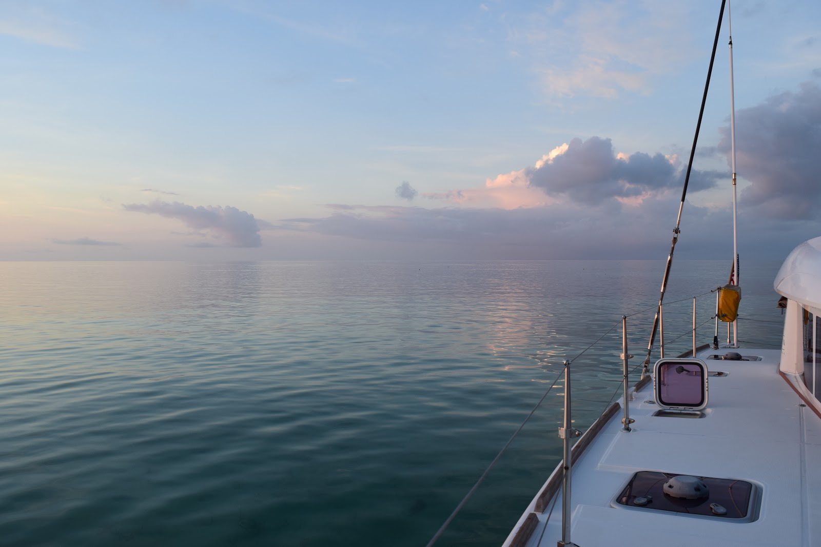
Upon our arrival in Florida after crossing the Gulf Stream, we needed to get to Key West in short order so we could check in. We spent the first night at anchor in Card Sound, on the inside of North Key Largo. The next morning we left early, as we were aiming for Bahia Honda, about 70 miles south.
 |
| Good ol' Florida sunset - Card Sound |
We had a really great sail, with light winds, but enough for a peaceful meander down the chain of islands that make up the Florida Keys. Our only hiccup occurred when we were sitting down for lunch, and Dave noticed that the auto pilot was making a strange sound. He sprayed it with some silicone spray, and then decided to continue hand steering. It felt like something was caught on the rudder or propellers. Luckily, it was calm enough for us to completely slow down, and Dave jumped in the water to have a look, and see if anything was caught. There was nothing. After continuing to alternatively hand steer and put it on auto pilot, he came to the conclusion that our auto pilot was just tired! It looks like the hydraulics may just be worn and will need replacing. After a whole loop around the world, and an additional trip across the Atlantic (by the previous owner), plus the trips we did before leaving on the circumnavigation, we reckon the auto pilot has more than served us well! We mainly hand steered from then on, to minimize any use of the auto pilot.
 |
| Sailing down the Florida Keys. Familiar marker buoys help us to stay in deeper water; dolphins come to greet us...it never gets old! Gaby enjoys the calm sail |
The first thing we noticed when we arrived at Bahia Honda was the lack of vegetation. We keep forgetting how hard all these areas, including the Florida Keys, were hit by the devastating 2017 hurricanes Irma and Maria. We had been to Bahia Honda quite a few times, both on Cool Runnings and our previous boat, and the walk up to the bridge and the view down to the anchorage was always through thick palm trees. Now the trees are gone, and a good portion of the old bridge looks like it was damaged. The anchorage is nestled between Henry Flagler’s old railroad to Key West and the Overseas Highway, that runs from Key West to the mainland, linking all the islands together.
 |
| Arriving at Bahia Honda. The old railway bridge in front with the new highway behind. A gap in the old bridge provides an entrance into a calm anchorage |
 |
| Henry Flagler's old railroad to Key West |
We stayed the night, and didn’t even go ashore, as we had not officially checked into the country yet. The following morning, we left early again, and headed down to Key West. It was a shorter trip, with about 40 miles separating the two destinations. We had dropped our sails and were motoring in the busy channel past Mallory Square and the busy Key West waterfront. A big cruise ship was docked in front of the Hilton Key West Marina, from which we departed in April 2016. Benjamin was at the wheel when we crossed our wake, our current track crossing over the one we made back then, completing the loop around the world! It was an emotional moment and we felt extremely proud of ourselves for what we had accomplished!
 |
| Celebrating our arrival in Key West and our moment of circumnavigation! |
Everything was familiar now. We went back to the fuel dock where we had filled up before we left. We enjoyed walking up and down Duval Street. We walked around Mallory Square, watching the street performers as we had done before we left. Except now we were feeling relieved, happy, proud. Then we were feeling excited, somewhat anxious and a little bit overwhelmed!
 |
| Meandering around Key West |
We allowed ourselves one night at the Galleon Marina, and then headed out at lunchtime the next day to start the final leg of our journey back home. We retraced our steps and sailed to Marquesas Key, roughly half way between Key West and the Dry Tortugas where we anchored for the night. The shallow water was crystal clear and provided a good opportunity to clean the hulls. They were not too bad, but Cool Runnings likes a clean bottom (don’t we all?! 😆), so we spent a few hours in the water giving her a good scrub. The following morning, we headed off to the Dry Tortugas, one of our favorite spots in Florida.
 |
| A breathless evening at anchor at Marquesas Key |
 |
| It's become Gaby's tradition to blow our conch at sunset. Ben pops his head out of his cabin hatch to watch the sun go down |
In Key West, Dave had purchased a book called “The Slumbering Giant” about the history of Fort Jefferson. It was short, full of old pictures and an easy read, so we all managed to read some, if not all of it before we arrived back at the fort again. While we had known most of the key facts about the fort, reading the book provided us with a little more insight into, and appreciation of, the enormity of building the fort, and the conditions of life at the fort back in the late 1800’s. Let’s just say I’m very glad I live in the 21st century!
 |
| Our drone captures this image of Fort Jefferson from the air |
Construction began in 1846 and continued for some 30 years, when, in 1874 the fort was abandoned by the army. It was never completely finished, and nor fully armed. It was never attacked, and a shot was never fired from it. During the Civil War, the fort was used as a prison, mainly for Union deserters, its most famous prisoner was Dr. Samuel Mudd, the physician who set the leg of Lincoln's assassin, John Wilkes Booth. 16 million bricks were used to build the fort, and it has 2,000 arches! The engineering of building this fort, with foundations that continued to sink, let alone the logistics of getting the materials to this remote location, is staggering. We have visited many times, and never tire of its history nor its beauty.
 |
| Images of Fort Jefferson: From the inside looking at one of the walls; the bricks, especially those facing the ocean side, are subject to some serious erosion. There was a lot of restoration work going on while we visited this time. Arches and moats and a selfie on top of the fort walls |
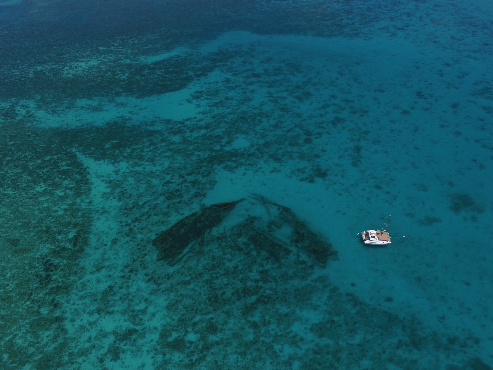
On Sunday June 3rd in the late morning, we took the boat over past Loggerhead Key and tied up to a mooring buoy which marks the wreck of the Windjammer. We had done this on Benjamin’s 12th birthday before we left, but on that day, the water was cold and the current was incredibly strong. Only Dave was able to really snorkel the wreck, while Ben, Gaby and I sat in the dinghy, ready to pick him up. This time, the weather was perfect, the water was warm, and the current was non-existent. In other words, it was a perfect day to snorkel the wreck.
The vessel has been identified as the Norwegian
Avanti, which sank January 22, 1907 while en route to Montevideo, Uruguay from Pensacola. The
Avanti, originally named
Killean, was an iron-hulled three-masted ship built in 1875 by the British company, John Reid & Co. It had a length of 261.4 feet, a beam of 39.3 feet, a draft of 17.5 feet, and a gross tonnage of 1,862 tons. This wreck site guide, taken from the National Parks Service website, identifies all the pieces of the wreck:
While the kids went off on their own, Ben on a paddle board and Gaby swimming alongside, Dave flew the drone to capture some incredible shots! If you turn the wreck guide image above, upside down, you can clearly see the wreck in the water below!
 |
| Cool Runnings next to the Windjammer wreck. The midship wreckage with the bowsprit and the main mast can be clearly seen...the stern wreckage is closest to our boat! |
 |
| The guide turned upside down to correspond with our photo of the wreck |
We were lucky that there was no wind and the water was crystal clear. The drone captured some amazing shots!
 |
| Ben paddles out on the SUP, while Gaby swims behind, exploring the wreck. Bottom right: The drone captures Loggerhead Key, with Fort Jefferson way in the distance |
We soon joined them, and together we explored the wreck, not caring about the huge Barracuda eyeing us, or the nurse shark resting on the sandy bottom. How times have changed!! Both Gaby and Ben dove to the bottom, swimming in and out of old port holes, checking out the coral, schools of fish, and identifying what parts of the ship were now resting on the sea floor. It was amazing to see how they have progressed, how comfortable they were in the water, and how they were able to appreciate such and amazing sight…not only what it offers us now in the form of recreation, but to understand the ship as it was in its day, how it hit the reef and sunk, and what it must have been like for the captain and crew aboard the Windjammer.
 |
| Diving the wreck |
Once back at anchor outside Fort Jefferson, we waited for the early evening, when the heat was a little more bearable, before we explored the fort again with our new-found knowledge. We noticed that there were many new informational signs posted around the fort, and a big lighthouse restoration project was underway. While we could definitely notice additional erosion on the windward facing fort walls, we could see that a lot of work is being done to restore the fort and keep it from falling into disrepair.
 |
| One of the new informational signs; Fort wall and moat; and the weathered bricks |
That evening, back on the boat, Dave did a weather download, and we started seeing the possibility of some weather coming our way. While we had initially planned to stay 3 – 4 days in the Dry Tortugas, we didn’t want to be stuck out there with our homecoming so close, so we decided to leave the following day, Tuesday, June 4th (which, coincidently, was our 24th wedding anniversary!). Our destination, Captiva island, was 124 miles away. Our typical 24 hour distance is 150 – 160 miles, or we can do about 80 miles in a full 12 day. In order to arrive in the morning, we needed to leave at about lunchtime, so we did a last outing to Loggerhead Key, where Dave flew the drone again. While he was flying, I heard some shouts of amazement…he had captured a huge Hammerhead shark chasing a Tarpon in very, very shallow water! That quickly put an end to any thoughts of jumping in the water for a quick swim!!
 |
| Cool Runnings anchored off Loggerhead Key; the hammerhead shark the drone captured - look how close it is to the beach! Do you recognize the lighthouse on Loggerhead Key? (Take a look at the header at the top of this blog page!) |
We did go ashore and went for a walk around the island. We noticed some major erosion here too, and while we remember some great snorkeling on the reef on the far side of Loggerhead in the past, there was no coral, and only rock left. We were so hot that halfway around the island, we decided to go for a quick dip. Keeping a sharp lookout for the Hammerhead shark, we sank into the cool water…only Ben forgot to take his phone out of his swim shorts pocket, and it sank to the bottom, where it rested for a few seconds before he realized what had happened! Even though we rinsed it as carefully as we could with fresh water, and immersed it in rice for a day to two to absorb any liquid, the damage was done. It only took a tiny bit of salt water to get into the phone, and it fried the circuit board. The phone, sadly, was as dead as a door-nail. Poor Benjamin…both he and Gaby had put in $100 of their own money in Australia to buy these phones…their link to their friends and the outside world.
 |
| Beauty on our doorstep: Cool Runnings at Loggerhead Key, Florida |
 |
| Exploring Loggerhead Key. Erosion caused this pump house to literally break in half! |
We anticipated a motor sail in very light wind all the way back across the Gulf of Mexico, but after a few hours, the wind actually picked up, and we were able to sail all through the night…the last nightshift of our journey!! We negotiated the pass into Pine Island Sound, looking for marker buoys that provide a safe passage past the ever shifting sandbanks, and with breaking waves all around us, we were thankful for the green and red buoys! We had arrived much earlier than anticipated due to the unexpected wind assist, so we sat outside the South Seas Marina debating what to do. We had booked a night at this much-loved resort. We have spent many a fun-filled holiday here, and the kids were looking forward to the resort’s water slides! Dave took his time getting mooring lines and fenders ready, while I stayed at the helm and hovered. Just before 8:00am, he tried the marina on the VHF, and amazingly enough, the person who had taking our booking over the phone the day before, answered the radio! He was just arriving at work and was walking to the office from his car. He called us back within a few minutes with a slip assignment. No problem accommodating us so early in the morning! We were met by two dockmasters who helped us tie up, and once again, Cool Runnings and crew were in a familiar spot!
 |
| Sunrise arrival at Captiva Island, and Cool Runnings at the South Seas Marina |
We made the most of our time at South Seas, enjoying the beautiful grounds, taking multiple rides on the water slides, and taking the trolley into the little holiday town of Captiva, where we enjoyed great Mexican food at Cantina Captiva, another place we had frequented before! We watched the sunset over the Gulf of Mexico, from the land this time and continued making plans for our homecoming. From the previous blog posts you’ll know that we kept moving up the date up, and it was here that we downloaded the weather again, and decided one last time, to make the final push home, to be back by Friday, June 8th. We were enjoying the familiar sights, but by this time, it was almost like we were just killing time, and we were so close, it seemed silly to stretch it out any longer.
 |
| Taking the trolley from South Seas to Captiva; Ben and Gaby at Cantina Captiva; Gaby coming down the water slide and sunset at South Seas |
After a last side down the water slide, we left the marina and entered Florida’s Intracoastal Waterway. We raised the main and unfurled the jib and had a fantastic sail on the smooth, flat water. The wind was about 15 knots from about 90 degrees and we reached all the way down the channel, avoiding the shallow water on either side. We could see storm clouds brewing on the horizon, and watched them to see which way they were moving…definitely towards us! After about an hour’s sail, and when the storm looked to be a little closer, we made the decision to drop our sails and we did this with possibly a minute to spare. The storm was upon us in no time, with heavy rain, and wind sustained 30 knots!! I suddenly remembered Florida’s afternoon thunderstorms! We had just arrived at our destination of Cabbage Key, but with the strong wind and pouring rain, we just dropped anchor just outside of the channel to wait out the storm. Once it passed, (and it did so pretty quickly), we weighed anchor and moved to a better spot where we settled in for the afternoon.
 |
| Before... |
 |
| During... |
 |
| And after the storm! |
The following morning, we took the dinghy to Cabbage Key, a small island with an old Inn and Restaurant on it. It also has one of areas oldest water towers that is still standing. Most others have been destroyed in hurricanes, but this one has stood the test of time and weather. We treated ourselves to breakfast at the little restaurant, and climbed the water tower, as we have done many times before!
 |
| Cabbage Key is on the National Register of Historic Places |
It was then on to our second last stretch before reaching home. We are able to navigate the Intracoastal waterway as far as Venice, after which time, we need to exit and continue sailing on the outside, as there are fixed span bridges that we don’t fit under. The majority of the Intracoastal Waterway bridges are 65ft high, and our mast is 70ft high. We had a couple of bascule bridges to pass through which opened either on a set schedule or on demand. We soon heard another boat on the radio asking for a bridge opening and soon we could see it. It was another catamaran. We were sailing (pretty slowly) and they were motoring, and soon they caught us up. We chatted on the radio and discovered that we had anchored together at Fowl Cay in the Bahamas! We recognized the dog they had on board! So we continued to move along together, allowing the bridges one opening instead of two.
 |
| Ben at the helm as he takes the boat through one of the bridges on the Intra-Coastal waterway |
Close to Venice there are 2 bridges in very close succession, and the last 2 before we spilled out into the Venice inlet. We passed through the first bridge together with Ohana, the other catamaran. Then we sat and waited for the second bridge – the last bridge we had to get through. The bridge tender said he was going to open for us, and we got ready. And then nothing happened. Soon the bridge tender was back on the radio. Only one side of the bridge was operational, and he couldn’t lift the other. So we waited. And waited. And waited. Back and forth on the radio. He said it would take a while as he needed to wait for maintenance to come and fix it. The space was tight for 2 big boats to try and hover and we eventually decided we would tie up to a small public dock and Ohana would raft up next to us. It was so frustrating being that close, and not being able to move forward! Just one more bridge and we would be free, but it was like being imprisoned!!
 |
| Ohana waiting for the bridge that couldn't open! |
Eventually, we heard the bridge tender on the radio, saying he would try and lift the bridge for us, but only the one side that was operational. We would have to squeeze through, and make sure our masts didn’t hit the top of the arm that was up. Ohana went first, and we squeezed through behind them. We were free!!
 |
| Ohana squeezes through one side of the bridge as we follow shortly behind. Ben and Gaby check to make sure our mast doesn't touch...it's a lot scarier when you're on the boat looking up!! |
We continued along to the Crow’s Next Marina where we tied up, almost in exactly the same place we had on April 17th, 2016. This was our first stop on our trip when we left, and it would be the last on our return! We enjoyed a lovely dinner at the Crow’s Nest Restaurant, and a restless night at the dock. Another storm came through with strong wind and swell coming in from the ocean. We were up a couple of times during the night checking and adjusting the lines and moving fenders. This was one thing I would not miss about cruising! We left early the next morning, motoring into the now calmer ocean, ready for our very last stretch, Madeira Beach, about 50 miles away! It was the last day of our circumnavigation. We would be home that afternoon. It was hard to comprehend! But Mother Nature had one more test for us before we were finally allowed to go home…


i am going to miss these blogs soooo much. Can you stretch it out a bit?
ReplyDeleteCongratulations Cool Runnings! Nice work closing the loop! Glad to read that you're back home in FL. Batu and her crew are back home as well; we sailed back to the West Coast from NZ. If you ever make it out to OR you must come for a visit! Now for the hard part...adjusting to life on land. Hugs and congrats all around!!
ReplyDeleteHi guys!! How awesome to hear from you! So glad you are also back safe and sound! That's quite a trip from NZ to the West Coast!! Congrats to you too! The invitation extends both ways. If you are ever in FL, please do come and visit...we might need a few tips on the adjusting to life on land part...!
Delete